Old Maps
Included here are four old maps, one of which is an aerial image of Western Reserve Academy before extensive construction and expansion programs of the past several decades forever changed it’s historic campus. See below:
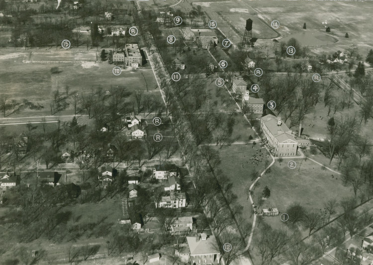
The change from then to now is night and day. Notice the number of buildings that don’t exist in this photo…No Ong Library, no Murdough Athletic Center, no turf field, no Morgan Hall, no Wilson Hall, no Metcalf Center, no maintenence garages, no Woodhouse, no Knight Fine Arts Center, and no Longhouse. This is WRA at it’s core, as it’s true self, before the modern day.
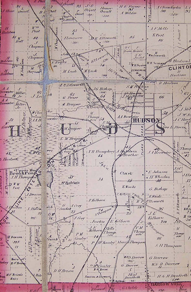
My intent in posting the following three maps is to emphasize the importance of trains and the railroad industry to the growth and development of Hudson. Keep in mind that today, only one line remains in service. That line is marked the “Pittsburg” line on the map below:
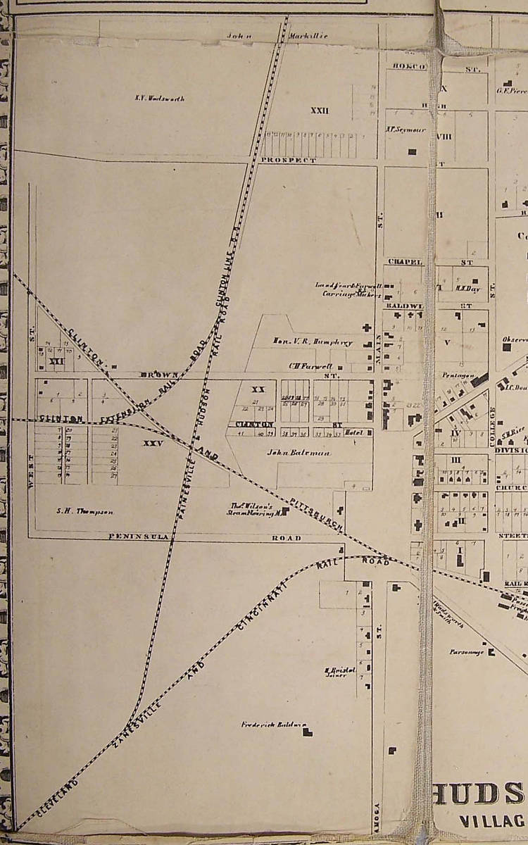
I thought I had seen every picture of Hudson’s old railroad lines until I stumbled upon the following two maps. With such volume of railways and railcars, one can imagine how loud life in Hudson must have been.

Pingback: Carnies in Hudson! « Hidden Hudson
Painesville & Hudson Railroad
http://www.trainweb.org/ceihsm/circa_1909.html
Old Railroad Line
Grading Completed, Bridges Built, but Painesville & Hudson Cars Were Never Run – Project Failed
Probably few of the present generation of Chardon people are aware that a partially completed steam railroad was built through the town over 50 years ago, but such is the case.
Early in the 50’s the Painesville & Hudson Railroad Co. was organized. Plans were perfected and surveys made, and soon afterward grading, etc., commenced on the line. A larger amount of stock was sold to farmers along the route, some of whom even mortgaged their lands heavily and sold large tracts to raise the money to pay for their stock.
The stated object of the Painesville & Hudson Railroad was to connect at the latter named place with the Cleveland, Zanesville & Cincinnati Railroad, which was constructed from Hudson as far as Millersburg, a distance of 60 miles, and thus furnish a direct shipping outlet from Lake Erie to the Ohio River.
Two routes for the railroad were surveyed by Engineer Chas. C. Smith. The “western route” was surveyed one-fourth of a mile west of Chester Center, and one mile east of the Mormon Temple in Kirtland, at which point the line was only four miles from the Cleveland & Erie Railroad, now the Lake Shore.
The “eastern route” crossed the Chillicothe Road three miles south of Chester Center, thence the line ran through Fowler’s Mills and Chardon. The Aurora Pond route from Chagrin Falls to Hudson was adopted.
On Sept. 11, 1854, a contract was entered into with Messrs. Callender, Barker, Chapin & Kittredge, for the construction of the entire line, including roadbed and superstructure, at the estimated cost of $17,600 per mile. At the annual meeting of the president and directors of the company in Painesville on Feb. 6, 1855, Engineer Smith, in his report, said there was no reason why the road couldn’t be finished and the cars running in the fall of 1856. But the cars never ran. The road was never fully completed.
From Painesville to Chardon the grading was completed over the route now traversed by the lake division of the B. & O. Railroad. The high stone viaduct bridge built south of Painesville, over which heavy trains run between Fairport and Pittsburg, was built for the Painesville & Hudson Railroad away back in the 50’s, but railroad trains never passed over it until about 20 years later, when a narrow gauge railroad, now recalled as the “old P. & Y.,” was built through from Fairport to Youngstown, as far as Chardon, over the old grade line of the defunct Painesville & Hudson route.
The viaduct bridge referred to is a fine piece of engineering work, and seems destined to stand for a half century longer. It has withstood a heavy ore and coal traffic for many years, and is claimed to be one of the best high stone bridges in the country.
Southwest of Chardon the route of the old Painesville & Hudson railroad followed the line now traversed by the Cleveland & Eastern electric railroad where the Chagrin River turns off east of Novelty station. Then it crossed just west of Russell Center, passed through one corner of Bainbridge, entered Chagrin Falls, and through Solon on to Hudson, the terminus.
The officers of the Painesville & Hudson Railroad Co. were: Van R. Humphrey, of Hudson, president; Benjamin Bissell, of Painesville, vice president; Henry Cram, of Painesville, treasurer; Geo. W. Steel, of Painesville, secretary. The directors included besides the above-named officers: A. C. Gardner, of Chagrin Falls; Erastus Spencer, of Claridon, and B. B. Woodbury, of Chardon.
It is probable that few, if any, of the officers or men who were directly interested in the project are living today. However, most of them lived to witness the completion of a steam railroad south from Fairport, for some distance over the same route they had sought to build a railroad nearly a score of years before.
Stone arch bridge over brandywine creek
Not sure if it is still there, but there was a stone arch bridge over the creek. It is located in the woods south of West Prospect. My understanding is that it was a railroad bridge. Maybe the Clinton Line?
Hi Bruce,
Thank you for the comments! I am very interested in the old stone arch bridge you mentioned, and am trying to pinpoint its possible location on Google Maps. Do you think it was located in the portion of woods between the current railroad tracks and W Prospect? I hope to explore this location soon – could be a great find! Again, thank you for the comments and for visiting my blog! Hope to hear from you soon.
Best Regards,
Bennett
I can pinpoint the location. But how do I upload an image?
I have a web page for you. see the website
Growing up in Hudson in the early 1950’s presented a great many of interesting opportunities. One such opportunity was walking the old roadbed of the Clinton Line from downtown North paralleling Main Street. Evidence of the roadbed could also been seen at the intersection of Aurora Road and Stow Road. On the northwest portion of the corner one could view the roadbed which was about 5 feet higher than the property surrounding it. On the Southeast corner of the intersectio9n was a small stone bridge which was part of the roadbed. Many enjoyable hours were spent fishing from the bridge. Other railroad walks included following the abandoned line behind Railroad Street. About a mile East of where it crossed Oviatt street were rusty protions of abandoned rail cars. Walking the old rail lines was a Saturday adventure for some of us.